Pawtucket – city, in Providence County, northeast of Providence at Pawtucket Falls, Rhode Island. Incorporated in 1862
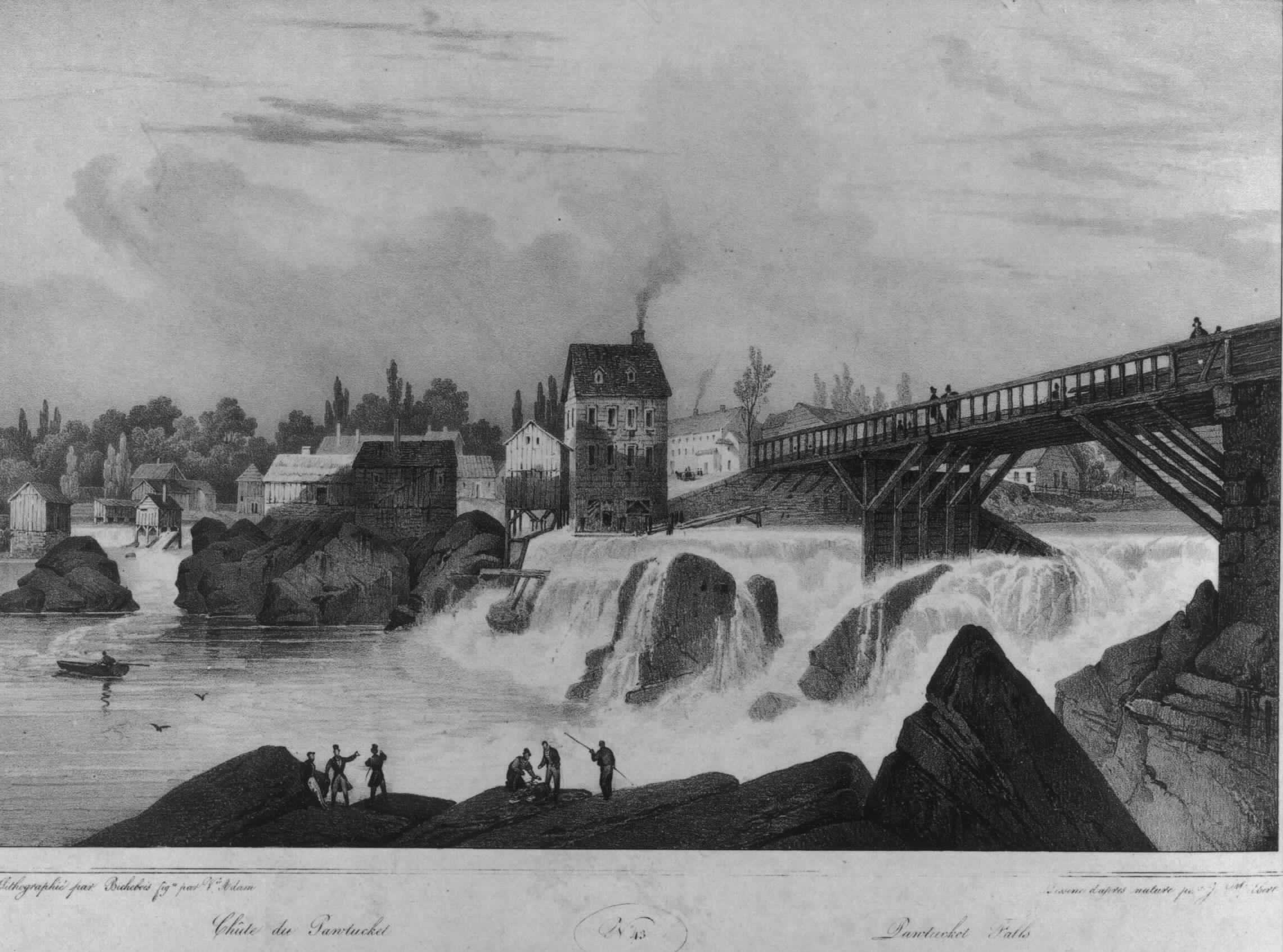
Pawtucket is on what is today known as the Pawtucket River. But a word is needed here to explain the river. The Blackstone River originates in Worcester, MA, and was a natural transportation route for the Indians and early settlers. The Blackstone river has a short wide stretch of shallow whitewater and then roars over the substantial falls at what is now Main Street in Pawtucket, RI.
Before the bridge across the river was constructed, the area of shallow whitewater above the falls was a natural crossing point for Indians and early settlers wanting to cross the river without having to resort to a boat on the broad and deep tidal area below the falls.
The area below the falls is a tidal arm of Narragansett Bay and was early known as the Seekonk River. The area closest to the present Pawtucket is now known locally as the Pawtucket River and the lower portion variously as the Seekonk River, even though geographers may think of the area as just being a fresh water tidal area of the Narragansett Bay. The Seekonk River flows (in proper tide time) down to meet the Providence River at the town of Providence.
In the native language “Pawtucket” means “great falls” and thus the place is named for the significant falls of the river.
The first part of modern Pawtucket to be settled was the part that is east of the Seekonk River. In 1651, This area was generally known as Rehoboth. This area known as Rehoboth encompassed both William Bucklin’s 600 acres, settled about 1645, and also the land of the later arriving Newman group who called their settlement “Rehoboth”. Rehoboth was in Plymouth Colony, in Massachusetts. This area immediately south of the Bucklin land later became part of East Providence, leaving the 600 acres of the Bucklin families outside of East Providence. In 1862 Massachusetts ceded that total area to R.I. The present southerly border between Pawtucket and East Providence (on the east of the Seekonk River) is the location of the former southerly boundary of William Bucklin’s original 600 acres, and is the place of the disputed boundary between Bucklin’s purchased land and the Newman congregation’s purchased land which the congregation named Rehoboth. (See Note 1 below.)
The second part of modern Pawtucket to be settled was the part that is west of the Seekonk river. In 1671, Joseph Jenks, who had been born in England and brought to Massachusetts by his father, came to the area across the river from William Bucklin’s land. Joseph Jenks is credited with being the first white person to build a dwelling on that side of the river. A skilled ironworker, Jenks erected a forge and set up shop on the west side of the river.. It was here that in 1793 Samuel Slater, with the financial backing of Moses Brown, opened the country’s first successful cotton mill, generally credited with starting the American Industrial Revolution.
The Jenck’s part of the modern Pawtucket ( west of the Seekonk River ) was originally part of the town of Providence, although well separated from the compact part of Providence, on the Providence River. This Jenck’s area was in the part of the Town of Providence that in 1765 was set off to be a separate Town of North Providence. The two separate political units that were involved with the economic reality of what is now Pawtucket, on the opposite sides of the river, were united as a single entity with one governing body in 1874. Then the Town of Pawtucket, Rhode Island was established with the boundaries as we know them today. In 1886, the Town of Pawtucket was incorporated as the City of Pawtucket.
The early history of Pawtucket involves the Blackstone River which is 45 miles long and runs from Worcester, Massachusetts through Pawtucket before flowing into Narragansett Bay. The natural course of the river served as a long-standing boundary between the Wampanoag and Narragansett Indian tribes. It was at the falls (under the Main Street Bridge) that major overland trails converged. The Indians called this place “Pawtucket,” their word for a larger waterfall. The shallow pools both above and below the falls made this a convenient place to cross the river. It was at this place, also, that the Indians gathered to fish for salmon, alewives, and shad, which ran in abundance well into the 19th century. On the east side of this important river area was where William Bucklin in 1651 purchased 600 acres, with a river frontage of about 2 1/2 miles. See more about this important 600 acres. On the west side of this important river was where William Jencks in 1671, set up his forge and did iron work, using the available supply of timber, nearby bog iron ore, and the river power. His forge was the start of an important capital accumulation for the Jenks family, and his son, Joseph Jencks, Jr., was elected Governor of Rhode Island in 1727 through 1731.
The small village around the Jenks forge by the time of the Revolutionary War had grown into a well-established community of iron workers whose products included farm tools, anchors, and then cast cannons an dmusekts.
From a social and economic standpoint, one village developed around the Pawtucket falls. This area was the place where the river could be crossed and people on each side of the river were closer to each other than they were to any other town or village. However, politically there were two distinct villages. the village of North Providence on the west side was part of Rhode Island. The village of Rehoboth (later East Providence plus Bucklin’s land retaining the situs of being in Rehoboth) on the east side of the river was part of Massachusetts. That 600 acre block of land on the north edge of Rehoboth and adjacent to the falls and for a mile downstream was owned first by William Bucklin and then by three successive generations of Bucklins.
The first mill on that east (Rehoboth) side of the river was built by the Jencks family on land they had purchased from the Bucklin family. But in 1741 the Jencks family built a larger mill, for more extensive manufacturing use of water power, on the west (North Providence) side of the river. They apparently regarded it as excess for in 1747 James Bucklin the 4th commenced the purchase of the “Corn Mill” on the east side of the Pawtucket Falls in Rehoboth, Province of the Massachusetts Bay. In successive years, he purchased one-half from Samuel & Experience Smith, one fourth from William Jenks of Providence, Colony of Rhode Island and the final one-fourth from Ebenezer Jencks of Providence, Colony of Rhode Island in 1750.
On the west shore of the river, the village of Pawtucket was part of Rhode Island. This west side of the river in the area of the falls was an area of ownership of members of the Jencks family. In 1789, Moses Brown decided to start his own textile factory. He purchased all of the important machines available in Rhode Island, had them moved to a rented fulling mill in North Providence (now Pawtucket), and hired his son-in-law, William Almy and his nephew Smith Brown (later replaced by Brown’s son, Obadiah) to operate the mill. Their attempts to operate the machinery were unsuccessful until they employed Samuel Slater.
 Samuel Slater emigrated to America in 1789 in hopes of making his fortune in America’s infant textile industry. While others with textile manufacturing experience had emigrated before him, Slater was the first who knew how to build as well as operate textile machines. Slater, with funding from Providence investors Joseph Jencks and Moses Brown, built the first successful water powered textile mill in Pawtucket, at the falls in 1793. He hired 9 children, ages 7 to 12, as employees, and the era of modern manufacturing in the United States began. Moses Brown, Jencks and Slater were the technology people of the age, and that side of the river became the place that is called the start of the Industrial Revolution.
By its 1796, the Slater Mill had 30 employees, mostly pre-teen children. Because large, poor families were an attractive pool of labor, Slater and the Jencks group built housing to attract them. This also concentrated the work force within easy walking distance to the mills. Since mill workers had to buy everything that they needed to survive, Slater/Jencks built company stores to provide for their needs. Paying wages in the form of credit at the company store also allowed them to retain essential cash to provide capital for continued rapid expansion.. To provide for his workers’ spiritual needs, Slater/Jencks built churches and established schools near his mills. Thus the west side of the river became the center of a growing industrial town.
 The Pawtucket Falls area quickly became the focus of textile manufacturing in the United States. (The picture on the left is of the Wilkinson Mill built in 1810 on the west side of the river.) The east side of the river, as well as the west side, developed large textile mills. Unfortunately for the Bucklin family, they had sold their land on the river by the time of the Industrial Revolution, and it was on the river the mills had to be built because of the need for water power for the machinery.
The two separate political units, on the opposite sides of the river, were united as a single entity with one governing body in 1874, when the Town of Pawtucket, Rhode Island, was established with the boundaries as we know them today. In 1886, the Town of Pawtucket was incorporated as the City of Pawtucket. Because of the larger commercial development on the Slater Mill side of the river, the founder of the joined Pawtucket City is thought of as being the first settler on that side of the river, Joseph Jencks.
Note 1: Complicating historical research further, when the East Providence town was formed east of the river, it did not include all of the area of Rehoboth. So the present town of Rehoboth does not present the larger area it once had.